Priest River Watershed Group
Check out the newly completed
2024-2034 PRWG Strategic Plan!
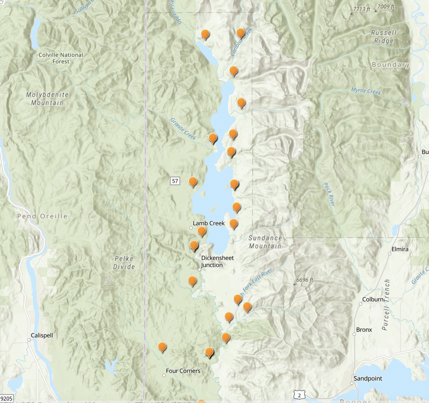
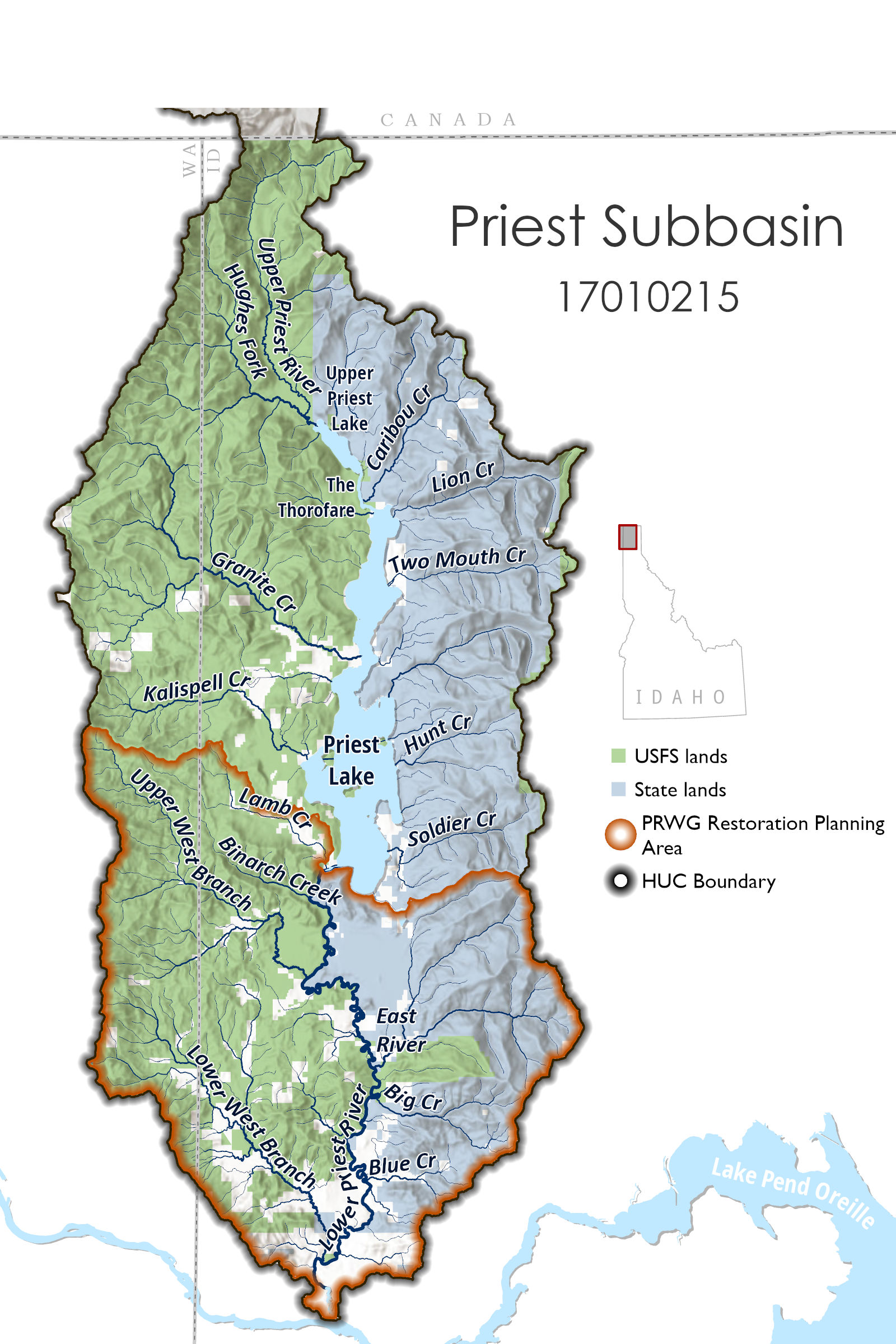
Where is and what waterways make up the Priest Basin?
The Priest River basin (HUC 17010215) is 981 square miles in size and is located in the northwest corner of the Idaho Panhandle within Bonner and Boundary counties. The watershed can be broken down into three identifiable areas for easy discussion: The Northern Headwaters; Upper and Lower Priest Lake; and the Lower Priest River.
The Northern Headwaters:
The northern headwaters of the Upper Priest River originate in the high elevations of the Nelson Mountain Range of British Columbia, and the Upper Priest River runs through Boundary County before flowing into Upper Priest Lake. Western headwaters of major tributaries originate in Washington State on a mountain crest that separates the Panhandle from the Colville National Forest in the Salmo-Priest Wilderness. Tributaries that originate in Washington State are contained in the jurisdiction of the Panhandle National Forest. The Selkirk Mountain Range rises on the east flank of the basin.
Upper Priest River (including Upper Priest Lake and Thorofare) and Lower Priest Lake
The Upper Priest River includes Upper Priest Lake and the Thorofare, a 2.5 mile river segment, which connects Upper Priest Lake to Lower Priest Lake. Large portions of the Upper Priest River and Lake are in roadless areas. The Upper Priest Lake Basin is home to both Bull Trout and Westslope Cutthroat Trout, Oncorhynchus clarkii lewisi, in resident and migratory populations.
The Lower Priest Lake is much larger than the upper lake, about 40 square miles in size, and a popular summer recreation destination. The east shores of the lake are adjacent to Idaho State Endowment lands, The Idaho Department of Parks and Recreation operates two state parks on the east shores of the lake, and Dickensheet Campground along Priest River just downstream of Priest Lake. Much of the western lakeshore is managed the U.S. Forest Service.
Lower Priest River and its Tributaries
The Lower Priest River begins at the outlet of the lower Priest Lake and Priest Lake’s Outlet Dam is located about a quarter mile down from the outlet of the lake. The Lower Priest River travels a sinuous path about 45 miles long with several significant tributaries entering along its length. Highway 57 travels west roughly paralleling the Lower River and connecting Priest Lake to the town of Priest River. The Lower Priest River empties into the Pend Oreille River, on the east side of town.
What are the primary concerns on the Lower Priest River?
- High summertime water temperatures. In the summer of 2021 water temperatures were recorded in the 80s!
- Low flows in the summer. Flows often drop below 300 cfs in the summer which violates the existing minimum instream flow water right which was set to protect fish and wildlife.
- Excessive sediment deposition in the river which resulted in the river being listed as “impaired” by the Idaho Department of Environmental Quality.
- Didymo, an aggressive species of freshwater diatom that can form mats on river substrate, is found in abundance on some parts of the the lower river.
- Degraded fisheries. Summertime fish kills were documented in 2021 likely from high water temperatures resulting in low oxygen levels. Bull trout populations are decreasing. Westslope cutthroat trout populations are not thriving even though they are abundant on similar North Idaho rivers.
- The Lower Priest River is morphologically degraded with minimal habitat diversity, it’s highly entrenched and disconnected from its floodplain.
- Manmade fish migration barriers, unpassable culverts and Priest Lake Outlet Dam block free movement of fish in a number of tributaries on the lower river, to Priest Lake, and to the high-elevation refugia located above Priest Lake.
- Decreasing functioning wetlands due to increasing land use and development.
Why did the PRWG form?
Trout Unlimited (TU) initiated the development of the PRWG to bring attention specifically to the Lower Priest River and to the degrading state of the fishery on the waterway. Recent attempts by agencies to address assorted issues had met public opposition due to the diverse and oftentimes competing water users in the basin. Solutions for the Priest River need broad public support, and development of a collaborative appeared an appropriate approach to prioritize implementable solutions for these complex issues.
What are the goals of the PRWG?
TU solicited and received a number of funding sources, including a Bureau of Reclamation grant, to support the creation and coordination of the PRWG. The primary goals of the PRWG may be summarized as:
- Effectively engage broad stakeholder participation in understanding the resource needs of the Lower Priest River Basin
- Provide education and outreach on the Lower Priest River.
- Work together to identify priority issues and explore ways to address those resource needs.
- Find ways to fill necessary informational gaps
- Create a prioritized restoration strategy that addresses the Lower Priest River Basin.
What PRWG is Working On
- Developing a Restoration Plan for the East River: The East River is a critical tributary to the Lower Priest River for fish. The PRWG is currently developing a restoration plan for this important drainage that will be completed by the end of 2025. This effort will help refine the restoration planning and prioritization process for the Lower Priest River.
- Gathering Information – The PRWG continues to gain information and host local experts to present on the Priest Basin.
- Communication & Outreach – The PRWG has developed an outreach plan which will guide our communications efforts moving forward. This effort will support increased engagement and educational outreach opportunities within the local community.
Temperature is a Primary Concern for the Priest River Watershed
The Priest River shares many of the aquatic habitat characteristics of medium sized Pacific and Inland Northwest rivers impacted by elevated summer temperatures, including high levels of channel incision, low summer flows, few side channels, and low levels of instream wood. The mainstem can reach very high temperatures in the summer which, in the worst of years, has caused fish kills. Understanding what the temperatures are on the tributaries and throughout the mainstem is essential to coming up with solutions to reduce temperatures in the main river.
Our partners at Idaho Department of Environmental Quality are working on this story map to organize and relay the findings in the temperature data. This is an ongoing project and the story map will change periodically as data is added.